Features Singapore MRT Map Route 新加坡地铁
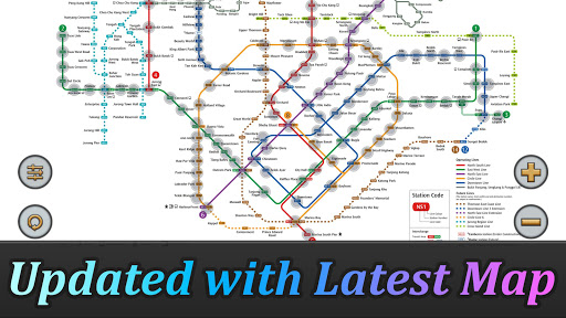
Added Thomson-East Coast Line (TE1 Woodlands North to Orchard) to the subway system.Singapores MRT system is extending.
By 2030, the MRT system will be more complex than you could image.
Its good for all residents on our lovely island.
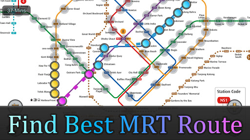
But also will be a problem because we dont know how to travel the fastest when transfering stations.Singapore MRT Map Route is designed to allows user to get the best route within a second.
It will help you save a lot of time over years.- View lastest Singapore MRT map- Display the best route between two stations- Automatically calculate estimated travel time- Require no internet connection.Updated to latest MRT system:Downtown Line(Blue)Bukit Panjang, Cashew, Hillview, Beauty World, King Albert Park, Sixth Avenue, Tan Kah Kee, Botanic Gardens, Stevens, Newton, Little India, Rochor, Bugis, Promenade, Bayfront, Downtown, Telok Ayer, ChinatownCircle Line(Yellow)Dhoby Ghaut, Bras Basah, Esplanade, Promenade, Nicoll Highway[C], Stadium, Mountbatten, Dakota, Paya Lebar, MacPherson, Tai Seng, Bartley, Serangoon, Lorong Chuan, Bishan, Marymount, Caldecott, Botanic Gardens, Farrer Road, Holland Village.
Buona Vista, one-north, Kent Ridge, Haw Par Villa, Pasir Panjang, Labrador Park, Telok Blangah, HarbourFrontEast West Line (Green)Pasir Ris ,Tampines , Simei , Tanah Merah , Bedok , Kembangan , Eunos , Paya Lebar , Aljunied , Kallang , Lavender , Bugis , City Hall , Raffles Place , Tanjong Pagar , Outram Park , Tiong Bahru , Redhill , Queenstown , Commonwealth , Buona Vista , Dover ,Clementi , Jurong East , Chinese Garden , Lakeside , Boon Lay , Pioneer , Joo Koon, Expo, Changi AirportNorth South Line (Red)Jurong East, Bukit Batok, Bukit Gombak, Choa Chu Kang, Yew Tee, Kranji, Marsiling, Woodlands, Admiralty, Sembawang, Canberra, Yishun, Khatib, Yio Chu Kang, Ang Mo Kio, Bishan, Braddell, Toa Payoh, Novena, Newton, Orchard, Somerset, Dhoby Ghaut, City Hall, Raffles Place, Marina Bay, Marina South PierNorth East Line (Purple)HarbourFront, Outram Park, Chinatown, Clarke Quay, Dhoby Ghaut, Little India, Farrer Park, Boon Keng, Potong Pasir, Woodleigh, Serangoon, Kovan, Hougang, Buangkok, Sengkang, Punggol
Social Features
Connect and share with friends and the community.
Gaming Features
Enjoy immersive gaming experience with various game modes.
Travel Features
Plan and manage your travels with ease.
See the Singapore MRT Map Route 新加坡地铁 in Action

Get the App Today
Available for Android 8.0 and above